trimetrogon — [trī me′trə gän΄] n. [< TRI + Gr metron,MEASURE + GON] a system of aerial photography in which three wide angle cameras are used side by side to take photographs of the earth from horizon to horizon … English World dictionary
trimetrogon — trīˈme.trəˌgän noun ( s) Etymology: tri + Greek metron measure + English gon : a system of aerial mapping involving the use of a single assembly containing three cameras with which one vertical and two oblique right and left aerial photographs… … Useful english dictionary
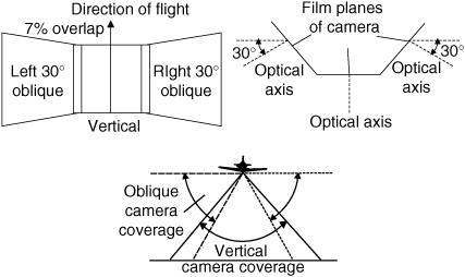
trimetrogon — /truy me treuh gon /, adj. of or pertaining to a system of aerial photography using three cameras, one pointed directly downward and the others at 60° to it. [1940 45; TRI + Gk métro(n) measure + GON] * * * … Universalium
trimetrogon — tri·met·ro·gon … English syllables
Executive Committee Range — Range SW view of Mount Sidley caldera Contine … Wikipedia
map — mappable, adj. mapper, n. /map/, n., v., mapped, mapping. n. 1. a representation, usually on a flat surface, as of the features of an area of the earth or a portion of the heavens, showing them in their respective forms, sizes, and relationships… … Universalium
Map — /map/, n. Walter, c1140 1209?, Welsh ecclesiastic, poet, and satirist. Also, Mapes /mayps, may peez/. * * * I Graphic representation, drawn to scale and usually on a flat surface, of features usually geographic, geologic, or geopolitical of an… … Universalium
MAP — See modified American plan. * * * I Graphic representation, drawn to scale and usually on a flat surface, of features usually geographic, geologic, or geopolitical of an area of the Earth or of any celestial body. Globes are maps represented on… … Universalium
B-47 Stratojet — Infobox Aircraft name=B 47 Stratojet type=Strategic bomber manufacturer=Boeing caption=Boeing B 47E 65 BW (AF Serial No. 51 5257) during rocket assisted takeoff test. designer= first flight=17 December 1947 introduced=June 1951 retired=1966, B… … Wikipedia
Marie Byrd Land — Map of Antarctica; Marie Byrd Land is in the bottom left between the New Zealand and Chilean claims … Wikipedia